Last month we discussed telematics systems. This time let’s focus on technology for last-mile delivery logistics. We’re bringing insights from Brian Larwig of Trimble MAPS. If Trimble sounds familiar, it should. You read about the company’s Construction Logistics division over the summer. Now let’s take a dive into its MAPS division that has solutions for last-mile delivery.

MWS: WHAT IS YOUR ROLE WITH THE COMPANY, AND HOW LONG HAVE YOU BEEN THERE?
LARWIG: I lead the strategy team at Trimble MAPS. I’ve got more than 17 years of experience in transportation technologies focused on efficiencies, automation, decision assist, and building data-focused solutions. I’ve been with the company for 11 years. Prior to that, I worked at UPS on automation and technology forward solution teams.
MWS: WE SPOKE ABOUT THE CONSTRUCTION DIVISION OF TRIMBLE OVER THE SUMMER. CAN YOU TELL US MORE ABOUT THE TRIMBLE MAPS DIVISION?
LARWIG: Trimble MAPS (Maps and Applications for Professional Solutions) is a newly formed division of Trimble, Inc. as of February 2019. Trimble MAPS was formed by bringing together Trimble’s former ALK Technologies and TMW Appian Final Mile businesses. The combination integrated ALK’s industry standard mileage, mapping, routing, and navigation with Appian’s fleet routing, scheduling, and optimization solutions. The result is a comprehensive platform designed to serve the entire commercial vehicle routing workflow from network modeling and strategic route planning to trip management and execution to real-time visibility and post-trip analysis. Trimble MAPS has maintained its core product brands, including PC*MILER® routing, CoPilot® navigation, and Appian™ routing and scheduling software.
MWS: ARE THERE ANY ADDITIONS/IMPROVEMENTS THAT HAVE EXPANDED THE PROGRAM?
LARWIG: Over the past 18 months we’ve launched and expanded a full-service development platform that allows fleets and technology providers to use our APIs to build or enhance custom solutions using our data and functionality. These APIs include access to our industry leading map intelligence such as precise geocoding, routing, optimization, and custom places.
A part of that launch included our new Trip Management service, a set of web and mobile APIs that offer insight and management of freight movement throughout its life cycle—from planning to execution to analysis. Using these APIs, fleets and solution providers can automate real-time visibility and ETA impact of current conditions like traffic and weather, as well as driver behavior on the road.
MWS: EXPLAIN HOW TRIMBLE MAPS HELPS DRIVERS WITH LAST-MILE DELIVERIES.
LARWIG: Using our connected mobility solutions, fleets can create custom workflows and forms, signature capture, and photo capture that drivers can easily use to make their jobs more efficient and streamlined. They can also send electronic manifests with line-level detail and delivery instructions.
On the road, we provide last-mile routing and navigation that takes into account commercial roadway restrictions and allowances for driver safety and compliance as well as voice-guided, turn-by-turn directions that use verified truck entry and exit gates where available for precise last-mile guidance.
MWS: WHAT ADVANTAGES DO FLEET MANAGERS USING TRIMBLE MAPS HAVE AS IT RELATES TO LAST-MILE DELIVERY THAT OTHER SYSTEMS DON’T OFFER?
LARWIG:
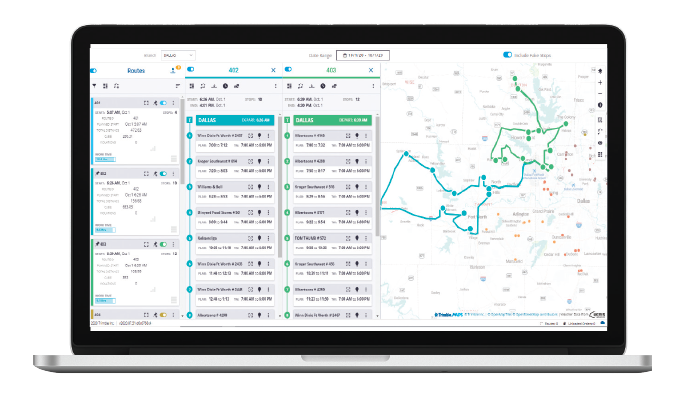
1. Comprehensive, all in one, end-to-end solution—Our Appian solution is built for the entire delivery logistics workflow:
- Fixed route design that inputs delivery time windows for on-time performance
- Daily routing to efficiently manage varying order volumes, capacity changes, and last-minute orders
- Dispatch and mobility to send routes and manifests to drivers; send delivery instructions; commercial grade navigation
- Real-time tracking to view route progress and dynamically changing ETAs to get ahead of service failures and/or provide customers status updates
- Reporting and analytics to evaluate average service times and delivery performance
2. Agility—Using Appian, customers can monitor routes, retrieve dynamic ETAs, stay ahead of any service failures, and track live weather and traffic conditions. This enables the ability to:
- Quickly adjust routes and gain insight to respond to customer needs
- Adapt to unexpected changes
- Meet customer delivery windows
- Provide delivery visibility to customers
3. Predefined and custom location data—Our maps have verified, pre-defined commercial location data that other map providers do not offer, such as:
- Truck entry and exit gates
- Specific boundary polygons for precise back office alerting of arrival, departure. etc.
- Location attributes like hours of operation, parking availability, and amenities
We also have tools that customers can use to create, manage, and share custom location and route management content, specific for their business needs.
MWS: HOW DOES TRIMBLE MAPS DIFFER FROM OTHER TRIMBLE SERVICES?
LARWIG: We focus on driving fleet efficiency through commercial map and location data and innovative routing, scheduling, visualization, and navigation solutions, all designed to solve the needs of commercial fleets, shippers, and delivery logistics companies worldwide. Our solutions are specifically designed for commercial vehicles and serve a broad range of industries, workforces, and commercial fleets of all sizes. We work closely with many Trimble divisions, including Construction Logistics, Agriculture, Transportation, FSM, and more.
Our core areas of expertise include: truck routing and mileage, fleet routing and scheduling, mapping and visualization, commercial navigation, trip management and ETA alerting, delivery time window optimization, developer tools, driver apps, and reporting and analytics.
FOR MORE INFORMATION
Brian Larwig leads the Strategy team at Trimble MAPS. Find out more, visit www.maps.trimble.com.


